
Blanked from the bank — every dawn and every dusk of this work trip went to the shore, and I didn’t put a fish on the deck.
The local read was simple: wrong week. The schoolers — the smaller class, roughly 1x to 30 inches, small in size but thick in numbers — had just moved off. The 30-to-40-inch class hadn’t pushed deep into the harbor yet; they were still holding in the outer water among the ring of islands, boat-only water. I’d landed in the gap between the two runs. By the locals’ count, the real heat was a week or two out.
Why shore work is mostly homework
Shore fishing demands far more pre-trip research than going out on a boat. In the three months before Boston I dug up spots every way I could, and once I was there a local friend walked me into a few places I’d never have found on my own. That intel is worth keeping, so this is the overview — the lay of the land — with detailed write-ups on individual spots to follow.
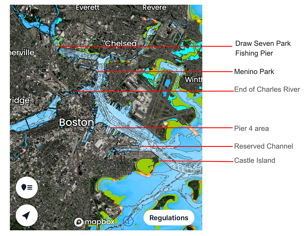
I built a working map in FishBrain, layering three views over the Boston area: satellite imagery on the land, nautical chart on the water, and FishBrain’s AI hotspot prediction on top. The orange-red zones are that AI layer — it crunches everyone’s logged catches plus environmental analysis of the satellite imagery to flag where fish are more likely to come close. Whether it actually works is a matter of opinion.
That map is just my own distilled overview of the area. It doesn’t mean these are the only places that produce.
A word on access
America has plenty of stories about private land — the walk along the shore that ends with an owner and a gun, or a call to the police. Massachusetts is different. The state works hard to protect public access to its coast: large stretches of shoreline have been bought into public ownership and turned into waterfront walks and other facilities, and the law guarantees public access to nearly the entire intertidal zone. Wandering onto private ground and getting run off is rare. If it happens, apologize sincerely and leave.
For fishing itself, the working assumption is positive — unless there’s a clear prohibition sign, you can fish. That said, some of those waterfront walkways are busy tourist thoroughfares during the day; for everyone’s convenience and safety, common sense says avoid them at those times. Carry the right license for the water and species you’re after and Massachusetts is a fine place to fish.
On safety — Boston ranks among the safest cities in the country, but caution still applies, especially late at night.
Reading the harbor
Look at the map and the structure becomes obvious: Boston is an estuary. The river mouth opens into a bay ringed by small islands, and that ring of land keeps the swell down. The days I was there, Windguru called 0.3m every morning — and aside from the wash from passing boats, the water genuinely sat as flat as a river. But because it’s an estuary working on the tide, the current still moves with real pace.
Most people’s consensus prime zone runs from south of the airport down toward Castle Island, on the outer side where the river flow meets the sea.
The nautical chart shows clear dredge cuts through the channel — this harbor handles large cargo traffic and needs deep shipping lanes. The dredged sections run roughly 10–15m; everywhere else the depth swings hard, anywhere from 2 to 10m depending on where you stand. Striped bass relate to structure, so when scouting a spot the key thing to read is whether there’s a sharp depth break on the bottom nearby.
The other priority is the shallow fresh-salt boundary. Boston Harbor is essentially a river system entering the sea through the Boston Main Channel, fed by the Charles and the Mystic. Both rivers have control gates where they meet the main harbor water. Above the gates it’s fresh — largemouth bass, white perch, perch. Below the gates it’s salt. That transition kills off microorganisms through osmotic shock, which draws filter-feeding baitfish in to feed, and those baitfish are exactly what stripers eat. Add that these spots usually sit around 2m deep — a perfect ambush box for bass — and the constant flow over the gates lifting dissolved oxygen, and you’ve got a standout mark you don’t pass up.
The spots
What follows in the detailed pieces runs through the marked spots from the river mouth outward. This is the overview; individual write-ups come later, with links here as they go up. So far:
- Castle Island
- Reserved Channel
The fish weren’t in this week. But the homework — the structure, the gates, the depth breaks, the bait logic — that holds for the next angler heading this way, and for me on the week the heavyweights finally swim in.